Last Updated on 22nd May 2025
Saltash is a Cornish town located on the border with Devon. It has a rich history dating back to the Bronze age. Saltash boasts a fascinating past due to its strategic location, overlooking the Lynher and the Tamar rivers, which has played a crucial role in its development. Saltash is the largest populated town in SE Cornwall. This walk takes in many historical buildings and places.

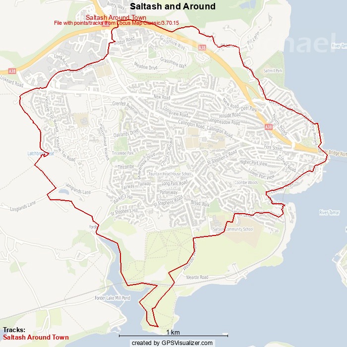
The route is just under 7 miles and follows the waterfront around to Forder Lake before heading back inland. It is a circular route, so it is possible to start anywhere along it and walk in either direction around it. For this guide, the walk starts at the north end of the A38 footbridge at Carkeel Roundabout.
Click here to download the GPX file for the Saltash and Around Route.
I am writing up a longer walk that extends out to Antony Passage and will be about 13 miles. This walk should get the taste buds going to explore more of this amazing area.
If you are new to walking or maybe want further hints and tips, read my article: A Beginner’s Guide to Hiking and Long Walks.
Start of the Walk
From the north end of the footbridge, walk east down the public footpath which hugs the north side of the A38 before heading NE and down to Pill Farm. This path can get pretty muddy, so suitable footwear is advised. It joins a lane that goes off to the right and then to the left onto Pill Lane. Turn right and walk down to Saltmill Park.
Saltmill Park
Saltmill, at Saltmill Creek, was once a tidal mill used to mill grain for flour for the residents of Essa centuries ago. In the last century it became a rubbish tip but, thankfully, it was developed to the wonderful football and playing fields, skateboard and BMX facilities you see today. This area is a prized asset to the town and attracts people from all over the area for the use of the facilities.
Continue walking along and up the steep hill, and round the corner to Old Ferry Road.
The Eastern Waterfront
Old Ferry Road, as the name suggests, leads to waterfront and the site of the Saltash Ferry. The road is a gentle hill down to the riverside with some amazing views of the two bridges.
The Tamar and its Crossings
As the road levels, look to the left to see a green. It’s worth walking around the footpath of this park to grab some beautiful views over the Tamar. Aside from the bridges, you’ll see the more industrial aspects of RNAD Ernesettle with its pier and pink flat-roofed building atop. To the north there are extensive views of the Tamar. The viaduct that you see in the distance is the railway over the opening of the River Tavy that leads to Tavistock and has its source way up on Dartmoor.
The River Tamar flows from Woolley Moor way up in North Cornwall. It marks the Cornwall and Devon county border and almost reaches the north coast. From Woolley Moor the border line lays to the west and just under Devon’s Welcombe Mouth Beach.
Continue walking along and under the two bridges. You can’t help but notice the Union Inn pub with it’s amazing Union Jack painted facade facing the river. Look to the left at this point, towards the river, and you see Ashtorre Rock Community Centre and Cafe. Always good for a cuppa and a bun.
The slipway between Ashtorre Rock and the pier is the site of the old Saltash Ferry. There has been a ferry at Saltash going back to the 11th century. There are historical sources suggesting the rights to this passage and its revenues passed hands several times over the years between the Duke of Cornwall and the Lords of the Manor at Trematon. It also gained rights by Acts of Parliament and more recent history, was granted stewardship by a Saltash Committee. Tamar Bridge was opened in 1961 as a road bridge, which marked the end for Saltash Ferry.
There’s a small children’s park with a steam engine climbing apparatus. Walk out towards the river and pier and there is a statue of Isambard Kingdom Brunel. Look to the skies and you see his masterpiece, the Royal Albert Bridge. It is railway bridge that was opened in 1859 having taken 5 years to construct.
Rowing and Sir Francis Drake
On a bench nearby is a sitting statue of Anne Glanville. The real Anne Glanville was born in 1796 and was a formidable woman. She ferried passengers and their goods across the Tamar, but her rowing skills soon got her into gig racing. Along with her crew, they became an unbeatable women’s team at regattas all over England. Anne became a world champion female rower. Sit and have a chat with her – she talks – and listen to her tales of what Saltash was like in her day.
Walk along the road and up in behind the Union Inn. On the left of the steep hill is Mary Newman’s Cottage. The cottage dates back to 1480 and Mary Newman (born circa 1552) is said to be the first wife of Sir Francis Drake. There is little known about Mary, but the cottage is a grade II listed reminder of a bygone age and visitor centre.
Walk a little further up the hill and turn left along Coombe Road.
Essa
There’s that name again. Coombe Road runs along the SE corner of Saltash and is in the suburb of Essa.
The town’s name, Saltash, is said to come from the Cornish, ‘Essa’. The word ‘essa’ is also Latin for water, which fits with Saltash’s location. It was also spelt Aysche during the 11th century. However, a family also named Essa were said to have lived near Ashtorre Rock during the 12th century. What isn’t readily explained is the ‘Salt’ part of the name. Apparently it was added to distinguish it from other towns having ‘ash’ as an ending. Salt was an expensive commodity way back, but evidence of Saltash being a salt centre is shortcoming. Essa is the oldest suburb of Saltash.
Coombe Viaduct
Continue walking along Coombe Road. There are some grand houses along this street on both sides that have wonderful views over the river. The road slopes down and through the Coombe Road Underbridge. It continues down and appears to come to an end, but this is just a messy bit of road from the debris of spring tides from the tidal inlet and woodland leaves from Coombe Wood.
Walk around and onto Babis Lane and look out to see Coombe Viaduct. This mighty stone and multi-arched viaduct, as with others in this area, replaced the trestle wooden constructions designed by Brunel.
It’s a shame that the local land-owners have erected fences. I get that they don’t want people parking on their plots, but to hide the magnificent views is overkill. There is a gap or two along the way to catch a glimpse of the viaduct and, especially on higher tides, it makes for a beautiful scene.
Continue walking until just the other side of the viaduct. To the right is a public footpath that looks to go back on yourself. It does this for a few metres, back under the viaduct, and then it hugs the side of it up to the same level as the rail track. If you are lucky you might get to snap a train hurtling past. The path emerges onto Deacon Drive. Turn right.
Wearde
Further up Deacon Drive, turn right onto Lynher Drive. After about 100m turn left. There are garages and a pre-school. To the right of the school entrance is a public footpath. This comes out in front of Saltash Community School.
This has to be one of the best schools for its stunning views over to Wilcove, Torpoint and Plymouth with Dartmoor scenes to the NE and Drakes Island to the SE. For me, this is coffee break. There’s nowhere to sit, so it’s a lean-on-a-fencepost stop, admiring the views.
Walk to the end of the school lane and head down Wearde Road. This area is known as Wearde. It’s a southern suburb of Saltash and once had an army training camp further down the road near Wearde Quay. This walking route doesn’t go that far down, but, if you have time, take a diversion to take a look.
Churchtown Farm Nature Reserve
A short way down the road is an entrance onto Churchtown Farm Nature Reserve. It comprises a number of undulating fields that have been provided to Saltash by Antony Estate that sits on the opposite banks of the river Lynher. The views and scenery from the Reserve are stunning and can dramatically change through the seasons.
There is a pathway heading SW and then in a gentle ark to head SE over 400m or so. It comes out at a gate and some steps down to a path that heads SW over Churchtown Farm railway bridge.
Just over the bridge there is a path on the left that leads down to a lovely river beach area. Watch out for the tides – mean high tide is fairly high up on the banks.
Continue walking down the bridal path to a field with a mound. You can continue around on either side of the mound, but the views from its top are worth seeing.
Across the river is Jupiter Point, a Navy training establishment. Moored up in the river is a Naval Minesweeper vessel that is also used for training. Look up and to the left of Jupiter Point to see the spire of Merrifield Church, which is on the outskirts of Torpoint. Turn to the west to see the buildings of Antony Passage. Around a bit further to the NW you can see the Forder rail viaduct and up to the left of it is Trematon Castle.
Head off NW toward the Forder rail viaduct. Note that the route to Forder is a permissive track and is not shown on Ordnance Survey.
Forder
The permissive track goes along the banks of Forder Lake, a tributary to the Lynher. It goes under another fine example of a multi-arched viaduct that looks very impressive from way down below. As you turn the bend the yachts, boats and olde-worlde buildings of Forder come into view. It feels like stepping back in time. In the winter months the smell of wood burners and puffs of chimney smoke add to the ambience.
Although difficult to comprehend in this picturesque village, Forder has an industrial heritage dating back to early medieval times. Lime burning, water transport, fulling (a process for cleaning and shrinking woven wool) and flour milling were amongst the many important businesses here. Today, Forder is a nice village to live or visit.
The path comes out in front of some cottages and out to the head of the lake in the centre of the village. Just around to the left is a nice sitting area with an information board.
Head upstream, north, and turn left after 50m, over a bridge and on up a steep bridleway. Around hallway up is Tor Hendra Farm and Tor House on the left.
Latchbrook
The bridleway comes out on Longlands Lane. Head down about 50m and turn left. There are sometimes cows at the gate here to say hello. Walk NW along the bridleway that leads to Wadgeworthy Farm. After 300m there is a public footpath access style on the right. Walk NE down the steep field to the gate at the bottom.
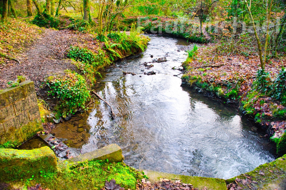
The gate opens to Latchbrook Leat. This is a tranquil wooded area with more a meandering stream than a leat running through. It’s a very fine example that demonstrates nature’s way with waterways – they are by their nature, bendy.

Walk SE along the Leat for a short way and then up and around NW. This public footpath follows the Leat out to the opening at Liskeard Road with Latchbrook House on the left. The House is listed and was built circa 1800.
Latchbrook is a housing estate today that gets its name from Latchbrook House. The area is shown as Burraton and Burraton Coombe on a 1919 Ordnance Survey map.
Back to the Start
Head NE up to the roundabout and turn left to walk along the industrial estate. After about 1km, cross over the busy road at the roundabout and head north. Lidl and Carkeel Gateway Retail Park are in this area. It can be a bit tricky crossing the road to the retail park. Over the road, follow the pavement or walk through the retail park and north opening to get onto the footbridge.
Up and over the footbridge. There are good views on a clear day from the top. There’s Dartmoor out to the east and on the other side, well, there’s a very confusing roundabout that always generates at least one blow of the horn from an angry driver as I walk over.
I hope you found this useful. Comment below to let people know your experiences of the area or anything you found when doing this walk.


