Last Updated on 24th July 2025
The St Agnes Headland is packed with dramatic coastal and inland scenes. Being on the north Cornish coast, the seas are often more turbulent with vivid colour and surf. Wild and rugged cliffs overlook vast golden sandy beaches. Surfers bob about on their boards waiting for the next wave to be generated from the strong ocean swells. You can breathe, smell and taste the salt air mixed with wild flower aromas.

There is a strong history of tin and copper mining in this area with the remains of many engine houses, chimney stacks and disused shafts. The Poldark series used parts of this area to film many of the scenes.
Walk Summary
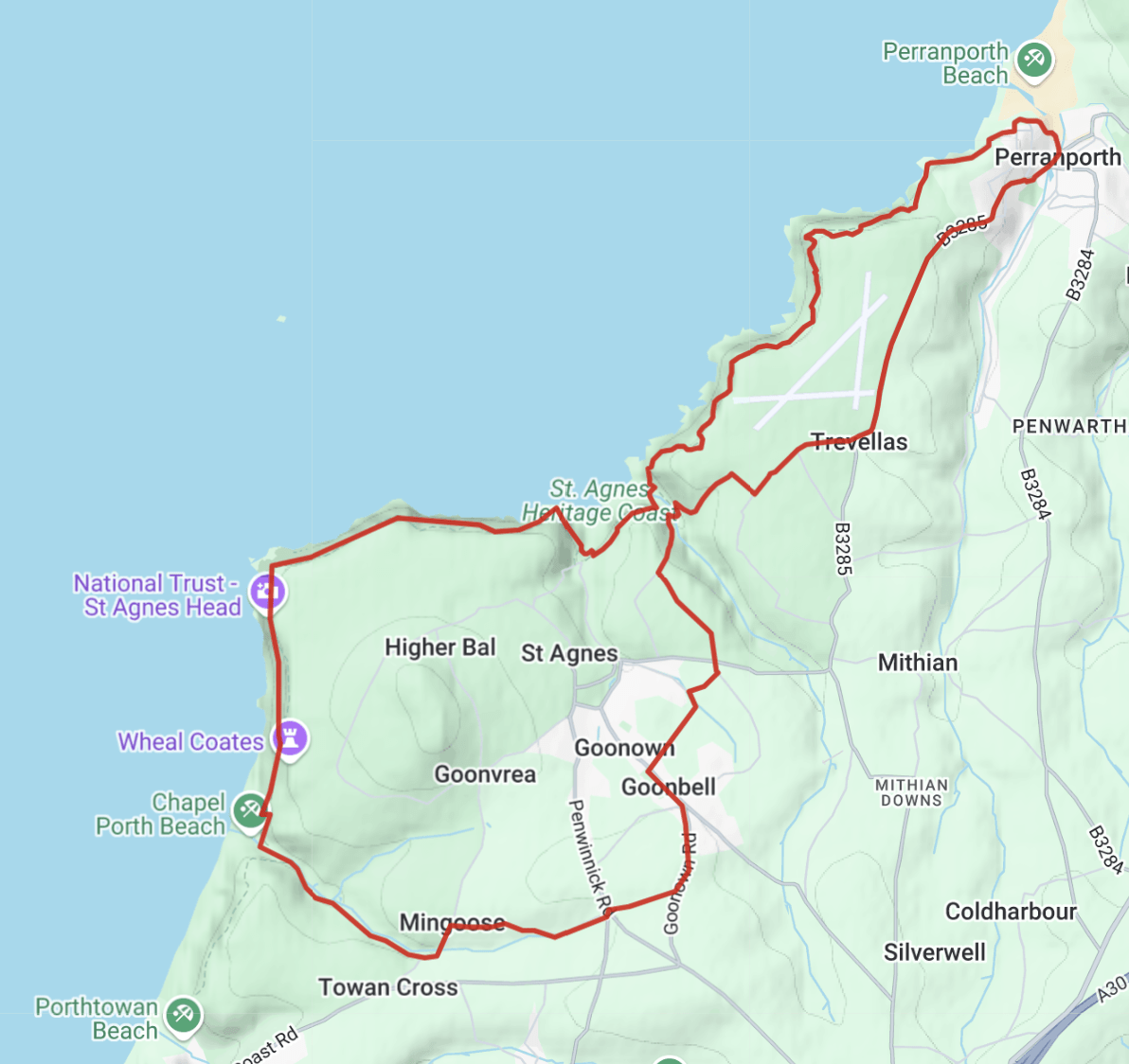
This guided 14-mile walk comprises of two figure-of-eight loops that starts at Trevaunance Cove. One to the north loops around Perranporth and back. The other is south, around St Agnes Head down to Chapel Porth. It follows a great deal of the SW Coat Path, as well as inland footpaths, lanes and some roads.
This is a full-day walk. Aim to set off before 10am, especially in the darker months. Expect it to take 6 to 7 hours. It can be done in less time if walking is more important than the sights to be seen!
If 14 miles seems a bit too far, consider walking one or other of the two loops. The Trevaunance to Chapel Porth loop is about 7.5 miles and the loop to Perranporth about 6.5 miles.
The route can also be viewed on Ordnance Survey Maps (you may need an account). Here is a GPX File for this walk that can be loaded into mapping software or apps. Here is my guide on using GPX files and technology – Top Tips: Mapping & GPS for Hiking.
If you are new to walking or would like some useful information, read my article, A Beginner’s Guide to Hiking and Long Walks.
Start of the Walk
Head for Trevaunance Cove (some refer to it as St Agnes Beach). Reppers Coombe Car Park is on the left on the beach road. The car park will likely fill up quickly in the summer months, so try to arrive around before 10am.
As this is a walk of two loops, it is possible to start anywhere along the route and to walk in any direction. This opens up opportunities to use local bus services or maybe start at one of the many local holiday camps or properties. Here is a great resource for Cornwall’s public transport.
Trevaunance Cove to Perranporth and Around
This is the northern loop of the overall walk, and can be taken separately. This guide takes the Perranporth loop in an anti-clockwise direction to walk the inland section first, returning along the SW Coast Path.
From Reppers Coombe car park, walk up the hill a short distance to the SW Coast Path heading NE. The path wends its way down into a valley of mining history with many disused shafts and chimneys scattered around and about. It arks around to the National Trust stone marked Trevellas Coombe. Carry on around to where the path links up with the lane at Blue Hills Tin Streams.
Lanes and Roads to Perranporth
The lane heads north for around 200m and then SE up the steep bank of the valley. It then arks around to NE along Cross Coombe. The lane then goes right SE to meet up with a road at Higher Trevallis Farm.


Head NE along the road to merge onto the main road to Perranporth. As it’s a main road, the traffic can be a little worrying, although it is a fairly open and straight road with good visibility.
There is an alternative road with less traffic further over to the east. It is accessed by following the easterly public footpath over the road from where the lane (mentioned above) merges onto the main road. There is also a lane to Carnbargus that links up with the alternate road, which then follows the river to Perranporth.
The main road runs alongside Perranporth Airfield, while the alternative road goes through Perran Coombe. Both roads merge at Perranporth. There are some small bridges over the river as the route heads north and then NW around the south end of the beautiful golden sandy Perran Beach.
Perranporth
It is in this area, it is said, that St Piran arrived in Cornwall having travelled over the sea from Ireland on a Millstone. There may have been lost translation in this version of events. However, he established an oratory or chapel in the dunes that flank the right-hand side of the beach in the distance ahead of this point. The remains can still be seen when wandering the dunes. St Piran is the patron saint of Cornwall.
There was a rich heritage of mining both tin and iron in and around Perranporth in both ancient and more recent history. The ore was transported to a quay at the river Gammel and out to sea at Crantock.
There was a train link to Perranporth that linked many north coast towns and villages. Sadly, Mr Beacham severed these services in the 1960s.
Today, Perranporth is an important tourist town and is a magnet to thousands of holiday-makers year upon year. People delight in the town, its beaches, scenery, walks and, of course, its surf.
There are many places to stop for a bite to eat or a drink, as well as supermarkets to pick up provisions for the journey. During the winter months, many shut up shop, but pubs, some cafes and the usual chains will remain open.
Perranporth to Trevaunance Cove
Continue west around and merging onto the SW Coast Path. Chapel Rock is to the right and, further on, there are some public toilets. A little further, there is a huge sun dial. After that, look down to see the outstretched rocks with a small holed opening.


The path leads out to Droskyn Point, which overlooks the beach from the SW corner. With binoculars on a clear day, the cross that marks St Piran’s Oratory can be seen over the dunes.
The coast path heads SW to Cligga Point. Fancy a break? There’s a bench along this section with amazing views over the cliffs and sea.


As the path shifts to the right and ascends to Cligga Point, take a look at the colour of the broken rocks that make up the path and surround it. There’s tin and copper in them there cliffs.
Around from Cligga Point, Bawden Rocks (Man and his man) come into view out to sea. Newdowns Head is the next landmark.
Light is reflected and refracted from the skies, and into and out of the water. Shallow waters are lighter than deeper seas. On a sunny day, the sea colours blend turquoise, greens and blues. It’s like being in paradise. On an overcast day, more green hues are often seen.

The coast path continues alongside the air field. It leads back to Cross Coombe and back into the Blue Hills Tin Streams valley to end this northern loop of the walk. It takes about 2.75 hours to complete, allowing for breaks and a bit of sightseeing along the way.
Trevaunance Cove to Chapel Porth and Around
This is the southern loop of the overall walk, and can be walked separately. This guide takes a clockwise direction around to Chapel Porth, retuning on the SW Coast Path.
Continuing from the northern loop, follow the lane, south, out of the Blue Hills Tin Streams valley. After about 300m, take the disused railway path heading SE. It passes by the remains of the Wheal Kitty mine. Incidentally, ‘Wheal’ is Cornish for ‘a working place’.


Rail Paths, Lanes and Roads to Chapel Porth
The rail path turns south and emerges onto a main road crossroads. Walk across and, a little further, take the right SW fork road. After a short distance turn onto another disused rail path heading SE and then turning SW.
The rail path emerges onto the main road at Goonown. Turn left heading SE. Further on there is a junction. Continue on the main road as it bends to the right, now heading south to Hurlingbarrow. One wonders where names like this came from.
At Hurlingbarrow hamlet take the westerly lane. This emerges onto another main road crossroads after a sharp bend. Walk across the road to continue westerly along the road to Mingoose. At the T junction, turn left.
The road heads SSW for about 200m. Take the bridleway path heading WNW.
The bridleway goes through a wood and then continues in the same direction as a footpath along Chapel Combe. Notice that this Combe has dropped an ‘e’. Both Coombe and Combe mean the same – a short steep valley. The path continues along the stream, low down in the valley.
This area is littered with disused mine shafts and stacks. As it emerges out onto the coast, up high to the south is Wheal Charlotte Moor.

The path leads to Chapel Porth beach. There is a lovely café with toilet facilities, but check for opening times if relying on this for food. They serve hot and cold food, dinks and snacks through a hatch and there are tables and chairs outside. Perfect for walkers!
If the tide is a fair way out, there are natural caves along the beach to the south and north, but check the tides. They are cut off after about mid-tide.
Chapel Porth to Trevaunance Cove
As they say, what goes down, must come back up again. Well, that’s the Cornish version! Onwards and upwards, north, out of the valley along the SW Coast Path. Further up the climb are the remains of the medieval chapel that gave Chapel Porth its name. It was built near a holy well and was dedicated to St Agnes.
The coast path splits a little further up. Take the left path, which goes around to the left and then heads north. Wheal Coates, and other disused mine works will come into view.
Wheal Coates
The remains of this mine are perhaps one of the most published mines in Cornwall. There is nostalgic beauty in the stone and surroundings of what’s left of the mine buildings. In the spring and early summer months, wild flowers adorn the landscape. The whole area makes for some of the best vistas and photographic scenes. All of this hides a much more austere, harsh and industrial past.


The mine was built in 1802 and was in copper ore production for 87 years. Life in the mines was brutal. From the age of just 12, boys and men would work until they were literally worn out by the age of 40. Their lungs would have all-but failed them with diseases like bronchitis, silicosis and tuberculosis. If that wasn’t enough, rheumatism would set in due to the very cramped conditions they worked in for prolonged periods. Many didn’t make it to 40. Accidents were common from blasting, flooding and unsafe machinery.
Women were employed as Bal Maidens. They wielded heavy hammers to crush copper ore into smaller chunks for transportation. In the early 1800s, some 7,000 children worked doing menial tasks above ground, and then the boys joining their fathers below ground.
Today, the National Trust maintains Wheal Coates. The SW Coast Path goes through the site and it is possible to take a look around the outside of the buildings for free. The site is also accessible by road with a NT car park. Sometimes through the year, the buildings are open for demonstrations.
On to St Agnes Head
The coast path continues north, past Tubby’s Head. It gently rises up and, looking back, there are dramatic scenes of Wheal Coates and the coastal cliffs to the south.
The coast path is high up too. People on the beach below appear tiny from this height. There are often surfers riding the waves, and people walking their dogs along the beach.
Continue further on to pass Carn Gowla. There is a car park above here, good for people to take to the coast path for short walks.

A little further on is St Agnes Head. There are a couple of big rocks and one further out to the north known as the Crams. Look up to the right to see the coastguard lookout.
The Return to Trevaunance Cove
From St Agnes Head, the SW Cost Path heads easterly and passes by the area, New Downs, and New Downs Head.
There are granite stone walls along the way with an abundance of wild flowers in the spring and summer months. The high cliffs overlook some interesting rock formations down below. Look out for the headland with the three caves at Polberro Cove.


A little further on, the coast path veers SSE and, from this headland, there are fantastic views over Trevaunance Cove and surroundings, including the disused mine buildings up on the cliffs.
The coast path emerges onto Trevaunance Cove. Aside from a look around and perhaps a well-earned ice cream, it’s just a short walk up the steep road back to the car park for the homeward journey.
This completes the south loop of the walk and it takes around 3.5 hours, allowing for a short lunch break at Chapel Porth.
End of the Walk
This is a great day out with lots of interesting and dramatic scenery along the way. In testing the walk for this guide, it started at 10am and took around 6.5 hours in all, walking about 14 miles in no particular hurry.
Doing this walk in the darker months, it would be best to start earlier, perhaps 9am. Also, check what is going to be open – maybe bring food and hot drinks just in case.
Share your experiences of this walk and nearby places in the comments below.